
Chapter 18 - Urbanization
Cities, Country Side, and Suburban
Urbanization is the societal trend where the proportion of people living in cities increases while the proportion of people living in the country side diminishes. Urban refers to the geographic territory within or close to a city. The governments of the world define urban in different ways, but it is safe to assume that between 2-5,000 inhabitants in a city is the minimum required to call a geographic territory urban. The World Population Review Website reported the top 10 largest cities in 2020 to be: Tokyo (37+ million); Delhi (29+ million); Shanghai (26+ million); Sao Paulo (21+ million); Mexico City (21+ million); Cairo (20+ million); Dhaka (20+ million); Mumbai (20+ million); Beijing (20+ million); and Osaka (19+ million). With all the rounded populations of the populations of the top 10 cities alone it totals about 235 million people living in only 10 very big cities! The same website list 533 other cities that have at least 1 million inhabitants in them. (“World City Populations 2020” retrieved 23 July 2020 from SOURCE). In the United States for 2020 the same website list New York City (42nd largest in the world with 8+ million); Los Angeles (103rd largest in the world with 4+ million); Chicago (175th largest in the world with 2+ million); Houston (205th largest in the world with 2+ million); Phoenix (289th largest in the world with 1.7+ million); and 33 others between 1.5 and 0.5 million inhabitants).
A PRB Report spoke to these trends (see PRB, Kaneda, T. & Greenbaum, C. (13 April, 2020). “How Demographic Changes Make Us More Vulnerable to Pandemics Like the Coronavirus” retrieved 21 July 2020 from https://www.prb.org/how-demographic-changes-make-us-more-vulnerable-to-pandemics-like-the-coronavirus/ ). This intriguing article shows how we are better prepared for this COVID 19 Pandemic than we were for the 1918 “Spanish Flu” but that we should not consider COVID 19 to be the last pandemic the world ever has to deal with. Why? The article points out some demographic patterns such as 4.3 nillion passengers flying in planes back in 2018; about 1.8 billion tourist visiting another country; as of 7 April, 2020 there were 1.5 million confirmed cases of COVID 18 in 183 different countries-only 5 months after the first case in China emerged! We have more and more large urban centers such as New York city which unfortunately is the epicenter of the cases and deaths from this pandemic. As of 2020 about 56 percent of the world’s population was classified as living in urban areas. There were 548 cities with 1 million or more inhabitants and as of 2018 there were 33 cities with 10 million or more inhabitants. New York is a megacity!
A few factors have to be in place in order for urban growth to occur. These theoretical approaches help in understanding urban development. Agricultural Surplus Theory claims that as farming skills increased, a surplus of basic foodstuffs existed. The surplus freed certain people from having to produce their own food and let them develop other occupations. Central Place Theory claims that farmers needed a central place to trade or sell their surplus and cities developed in those central places. Trading Theory claims that the surplus was not as important as were the specialists who knew how to create it and do other occupations. There must also be a transportation route (river, trail, valley, railroads, harbors, or oceans). Once settlers move in, the city will flourish or fail depending on its ability to continue to draw in people seeking opportunities.
Rural refers to the geographic territory in the less populated regions of a society. The U.S. Census (2019) estimated that from the 2010 Census and other estimates that of the 3,143 total U.S. counties, 1,254 were mostly urban (40%); 1,185 were mostly rural (38%); and only 704 (22%) were “completely rural Counties.” Estimates continue to point toward increasing. Urban areas with decreasing rural areas (Census 2019 “Our Rural Communities” retrieved 23 July, 2020 from SOURCE).
In 2017 the PRB published a report on recent studies about rural areas, focusing specifically on the demographic changes recently impacting them. Some of the highlights were very insightful. Daniel Lichter taught about the “three-Ds” that are changing rural America: depopulation, death, and diversity. Younger people are moving out of rural America. Hispanics are either remaining in or migrating to rural America. And elderly people (who often stay rural after retirement) eventually die. Jennifer Van Hook reported that 9 out of 10 rural areas were more diverse in 2017 than they were 20 years before. Merideth A. Kleykamp reported that “Roughly 18 percent of the total U.S. population lives in rural areas compared with 24 percent of all veterans. Additionally, 36 percent of veterans who use the Veteran’s Administration (VA) for health care live in rural areas, and distances to VA facilities pose challenges.” (All three reports found on PRB (26 April, 2017) “Changing Demographics Reshape Rural America” retrieved 23 July 2020 from SOURCE).
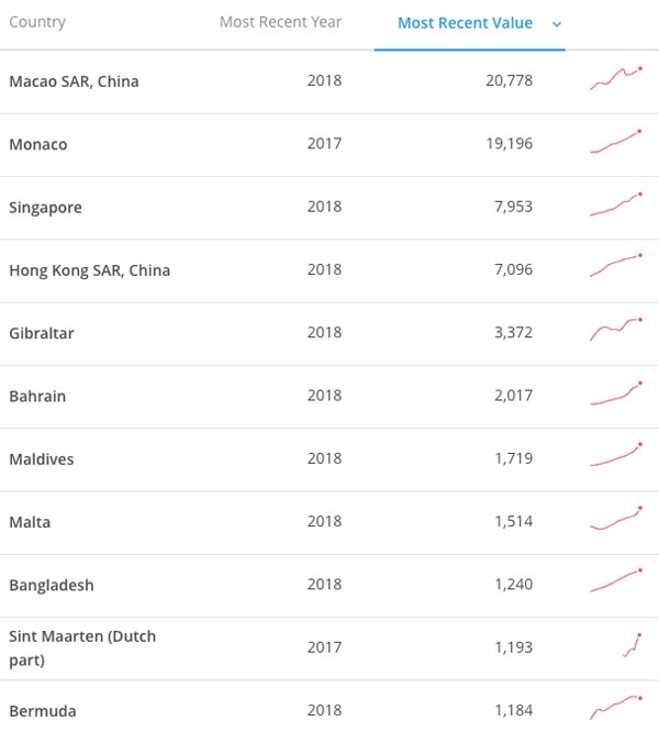
Sociologists who study the cities often use this simple concept called Population Density=the number of people per square mile or square kilometer. The WorldBank published a recent estimate (1961-2019) of the highest regions with the highest population densities per km2. Figure 1 shows the most densely populated 11 countries. As you look at their people per km2, keep in mind that the U.S. only has 36/km. Contrast that to Macao with 20,778 people/km2 and Monaco is close with 19,196 people /km2 . Then it drops dramatically to the next set where Singapore (7,953/km2) and Hong Kong 7,096 /km2.
Then it drops a bit further again. Still, the 11th most densely populated country in the world (Bermuda with 1,184 people /km2 is still over 32 times more densely populated than the United States and the most populated country (Macao with 20,778 people /km2 was a staggering 577 times more densely populated than the United States! The WorldBank also shows a recent trend line indicating the last 6 years of population density (look at that small red arrow-tipped line on the right). The overall trend for the top 10 is increasing population density. Bermuda had a slight recent decline (recent hurricanes).
Figure 1. WorldBank* Population Density per Square Kilometer of Land*
The United States Road System
The United States has become increasingly urban since its formal inception in 1776. Washington D.C. in 2000 was 100 percent urban while Vermont was only 38.2% (retrieved 14 April, 2009 see Table 28. Urban and rural Population by State from SOURCE ).
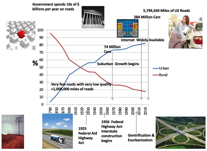
In Figure 2 you can see the increasing urbanization in the US (the blue line) and some of the factors that contributed so strongly to it after 1940. There were 2 key pieces of legislation that made the development of today's interstate and road system what it currently is. The 1925 and later 1956 Federal Highway Acts facilitated the federal control, organization, and funding of nation-wide road development. Prior to these acts many roads were impassable, or very poorly maintained.
A nationally coordinated numbering system was put into place and after 1956 billions of dollars were earmarked to fund the asphalt and concrete paving of a new highway system. Today we have over 4 million miles of roads that require tens of billions per year in construction and maintenance costs. You can also see that car ownership increased dramatically once the roads were built. The number of cars owned tripled between 1960-2000 and these cars facilitated the commuting trends into the suburbs. The availability of the Internet facilitated working from home and telecommuting. For the wealthy elite, gentrification and exurbanization was made possible by abandoned factories and apartment buildings, now desirable for purchase and renovation by the upper-middle class young couples.
By 1980s, many empty warehouses and many abandoned apartment buildings scarred certain sections of the city. Wealthy young couples began a trend called Gentrification, or the purchase of rundown buildings in the city center that were remodeled for upper class apartments. Inevitably, gentrification forced the poor inner city dwellers out of their neighborhoods, because city officials were persuaded to rezone these gentrified neighborhoods to keep the "undesirable elements" away. Around the 1990’s another trend emerged called Exurbanization, where upper class city dwellers moved out of the city beyond the suburbs and lived in high-end housing in the countryside. Truly, the modern US urban experience has followed a semi-circular pattern in the last 150 years, following this pattern: Rural habitation _ Urban habitation _ Suburban habitation _Gentrification for wealthy _Exurbanization for wealthy. Figure 2 summarizes some of the key historical factors that brought current US urbanization to the point of over 7 out of 10 in the US living in urban areas, following this historical pattern: Industrial Revolution _ World War II _Transportation expansion _ Technological Revolution (computer chip).
Figure 2. Percentage of United States Population Urban and Rural*
Why live in a city in the first place? One explanation goes back to the Push and Pull Factors we learned about in Chapter 17. Push factors back home might include: too many people and not enough jobs or food; too few opportunities; almost everyone is poor in rural areas; and there are often severe taxes in rural areas. Pull factors toward the city typically include hope of better jobs, opportunities, reunion with family members, and lifestyles. In general over the last 100 years the rural economy provided fewer and fewer opportunities, services, and culturally desirable experiences in comparison to the urban one. People are literally pulled to the urban and suburban areas because the city offers more of these unmet needs. The Industrial Revolution brought many workers to live in and around the urban areas. Factories and inner city concentrated housing units were very common up until World War II.
By the end of the war, people wanted their own homes, independence, and a daily reprieve from the grind of the big city. They didn't want to move too far away, just far enough to allow them a less hectic daily life with a more affordable cost of living. The suburbs came at a perfect time.
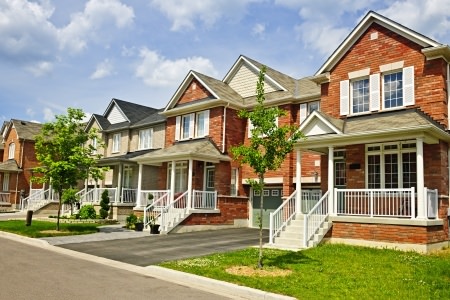
Suburban refers to smaller cities located on the edges of the larger city, which often include residential neighborhoods for those working in the area. The suburbs in the US grew dramatically after World War II when the superhighways and freeways combined with the somewhat modest cost of automobiles; the movement out of the inner city and into the suburbs was on.
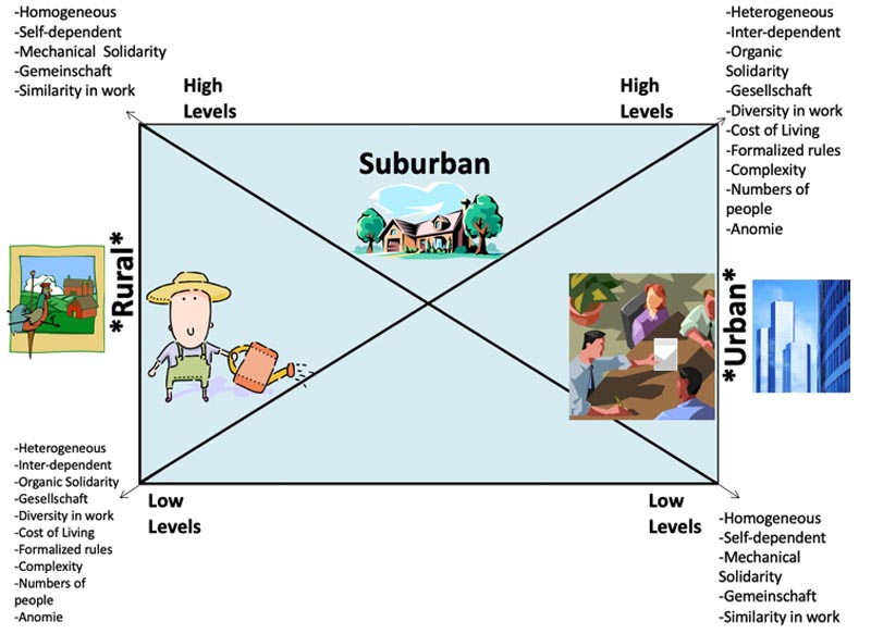
Look at Figure 3 below to see the characteristics of rural, suburban, and urban social structures. On the left side of this graphic, notice that rural areas typically have high levels of homogeneous people (they are very similar), self-dependence, mechanical solidarity, and similarity in work. Urban areas have relatively low levels in each of these. On the right hand side, notice that urban has heterogeneous people (very diverse peoples), inter-dependence (the doctor needs the butcher, the butcher needs the accountant, the accountant needs the electrician, etc.), organic solidarity, diversity in work, higher cost of living, formalized rules, organizational complexity, numbers of people, and anomie. Rural areas have relatively low levels in each of these. Suburban areas have a relative mix of all of these traits, some higher and some lower depending on other structural, cultural, SES, and historical factors.
All of the definitions in this paragraph were discussed in other chapters, but for the sake of quick reference they are repeated here.
- Homogeneous implies similar types of people whereas Heterogeneous implies diverse types of people.
- Gemeinschaft (Guh-mine-shoft) means "intimate community" whereas Gesellschaft (Guh-zell-shoft) means" impersonal associations."
- Mechanical Solidarity is a shared conscious among society's members who each has a similar form of livelihood whereas Organic Solidarity is a sense of interdependence on the specializations of occupations in modern society.
- Anomie is a state of social normlessness, which occurs when our lives or society has vague norms.
World Trends
Figure 3. Graphic Depicting: Rural, Suburban, and Urban Societal Characteristics
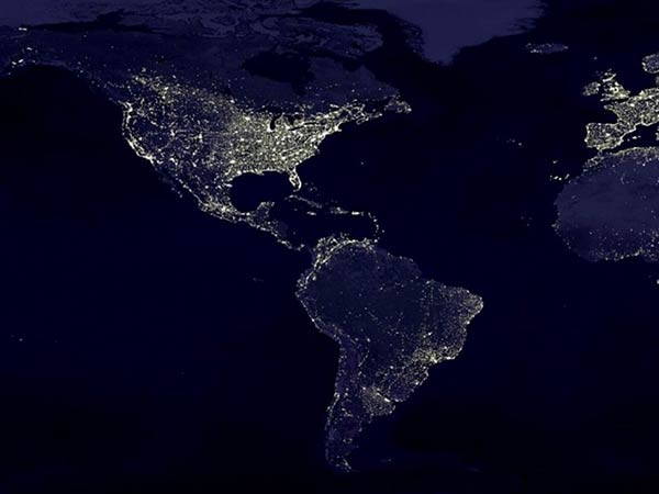
The 2008 Population data Sheet from the http Composite map of the world assembled from data (acquired by the Suomi NPP satellite in April and October 2012. Retrieved 28, May, 2014) website stated, "The world will pass a milestone in 2008: One-half of the world's residents will live in urban areas. This event is impressive when we consider that less than 30 percent lived in urban areas in 1950 (page 5)." Look at Figure 4 below to see NASA's amazing time-lapsed, night time photograph of the Americas, Western Europe, and Western Africa. From this satellite photograph you can see the population concentrations throughout the US, South America and Western Europe in contrast to the relatively sparsely lit Western Africa. This not only represents fewer numbers, but also less utilization of rather expensive electrical lights in the urban areas. You can barely distinguish Canada from the US. This is because most Canadians live in the lower portion of the country where the climate is more conducive to human existence.
Figure 4. NASA's Photograph of Americas, Western Europe, and Western Africa*
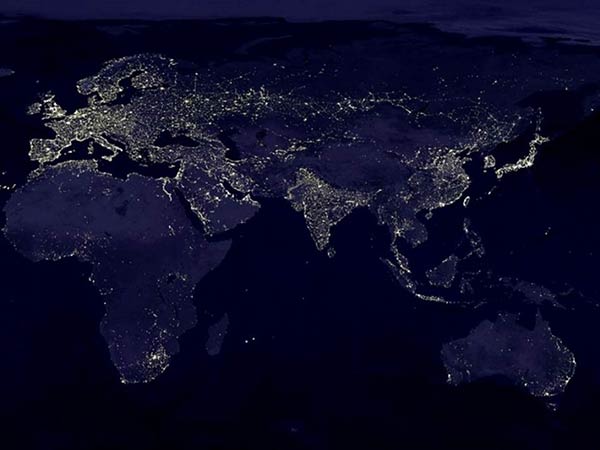
In Figure 5 you can see the NASA night photo of the rest of the world (not including the north and south continents). On the left side of the photograph it becomes obvious that most of Africa is not as lit up as are the other regions of the world. There are nearly 800 million people currently living in Africa. Electricity and city lights are very expensive based on the standard of living there. Notice the lights of Europe, Russia, The Middle East, India, Eastern China and Asia, the Island nations and the outer boundary of Australia. These light concentrations are in and near major cities and photographically distinguish the differences in socio-economic status between these regions of the world. They also identify the world's urban areas in a clear way.
Figure 5. NASA's Photograph of Americas, Western Europe, and Western Australia, and Island Nations*
Look again at the United States back in Figure 4. You can see a massive cluster in the North-eastern region. The clusters represent what sociologists call a Megalopolis, which is an overspill of one urban area into another often where many small towns grow into one huge urban area connected by a major transportation corridor. Some of the larger ones today include: Boston-Washington; Chicago-Pittsburgh; and New York-New Jersey. A megalopolis often has 10 million or more people living there. These are found in Europe, Asia, India, Mexico, and Japan. A megalopolis is comprised of Metropolitan Areas, or large population concentrations in cities that have influence of the cities various zones. Each city has a number of zones of influence within its boundaries.
Theories of Urban Development
Human Ecology studies the form, structure, and development of the community in human populations. Ernest W. Burgess developed the Concentric Zone hypothesis of city development in his work, "The Growth of the City," in a 1925 publication (see The City by Park, R.E. and Burgess, E.W. eds U. of Chicago Press, 1967). Burgess was from a very influential sociological program called the Chicago School and he believed that a city grew out much like the trunk of a tree with concentric zones. The Concentric Zone Theory claims that cities grow like the rings of a tree, starting in the center and growing outward.
He identified the following zones: Central Business District; low, middle, and high class residential zones; heavy and light manufacturing, and commuter and suburbs zones to give a short list. Each zone has its realm of influence on the daily lives of city dwellers. Although Burgess' approach has been highly modified, it proved to be a classic in studying the nature of cities. Another scientist named Homer Hoyt noticed that not all city patterns were concentric and he devised a theory to study the pie wedge-shaped zones he came to call "sectors." The Sector Theory claims that cities grow in pie wedge shapes as the city develops (see Hoyt, H. 1939, "The Structure and Growth of Residential Neighborhoods in American Cities;" published by the US Federal Housing Administration, Washington, D.C.).
Later, in 1945 Chauncy O. Harris and Edward L. Ullman wrote a scientific piece in the Annals of the American Academy of Political and Social Sciences called "The Nature of Cities" (page 242 published by Sage publications). Their approach came to be known as the Multiple Nuclei Theory, which claims that cities have multiple centers (Nuclei) that yield influence on the growth and nature of an urban area. These scientists cleared up the issue that a cities growth and development can be universally predictable. They and many scientists since them have established that some commonalities can be predicted, but each city has its own unique history, culture, geography, and resources.
In 2006, an article entitled, "Growth and Change in U.S. Micropolitan Areas" was published by Mulligan, G. F. and Vias, A. C. (see The Annals of Regional Science, Vol. 40, No. 2/ June, 2006 pages 203-228). The relatively new concept of a Micropolitan was discussed. A Micropolitan is an urban area with 10,000-49,000 inhabitants. Mulligan and Vias reported about 581 micropolitans counted in the 1990 US Census. The city I live in Payson, Utah is a Micropolitan. When I first moved my family there it had 3 red lights and we counted them. It had a vending machine with live fishing bait on the main corner at the first red light. The US Census has a service called QuickFacts United States pick a state then the city and click "go" and you can find these details for most US cities).
There are many other official classifications used by Government and educational scientists to study the urban, suburban, and rural experiences among society's members. Let's just learn one more concept that will help you to understand the US Census Bureau's approach to segmenting and analyzing cities, counties, states, and the nation as a whole. A Metropolitan Statistical Area includes one or more adjacent counties that has at least one 50,000 populated urban center that influences the economic, transportation and social connection of the area.
Cities: Good or Bad?
For centuries, philosophers and scientists have studied the value of cities in contrast to rural settings. Historians provided records of ancient cities dating back thousands of years BC. Scientists from other disciplines studied the historical documents to derive their structure and function. From these and contemporary studies they've drawn modern-day conclusions about how cities best work. In the early US history there was an intensive debate about the nature of the city as being evil. Many felt that the smaller, spread out cities supported better physical and mental health (although little science went into their claims). Some claimed that the mega city had the best to offer and architects laid out enormous city plans, some using mega-buildings, others using parks and grids to create the ideal city plan that attempted to balance urban traits with rural ones. Many of these plans were utilized in the development of suburbs.
Individuals often weigh in on the debate. Urbanites are drawn to the city for a number of reasons including: the energy, diversity of people, dining and entertainment, safety (yes, many people feel safer in cities), cultural events, and sporting events. Those not attracted by the city are repulsed by: fear of crime, large numbers of people, expensive costs, congestion, and crowding. I remember one of my students expressing how afraid he would be of having an accident out in the countryside and no one being there to provide help. Another student added that he was afraid of psychotic children jumping out of a cornfield and killing any strangers who wandered by. Yet another student chimed in that he felt just as much in danger in the city because there were so many different types of people and unless you were "street smart" you couldn't distinguish the bad guys from the good ones.
Herbert Gans published an important work about the types of people who live in cities. In many ways his ideas still apply today (see Gans, Herbert 1968. "Urbanism and Suburbanism as Ways of Life. A Re-evaluation of Definitions." In People and Plans, pages 34-52, Basic Books: NY.) Gans focused on the life-style of the city-dweller as much as the demographic background. Cosmopolites are intellectuals, professional, and artists who are attracted to the city because of opportunities and community that are found there. Unmarried Singles aging in the 20-30's typically enjoy the city-singles scene and will probably move when they get older or marry. Ethnic Villagers are city dwellers who group together with others of the same ethnic background and set up miniature enclaves. The Deprived and Trapped are the very poor, disabled, or emotionally disturbed who are often victims of other city dwellers.
Certainly Gans' descriptions have merit in our day. We might add a few other categories since over 40 years have passed since his work was published. On one hand we might add opportunist who see the big city as providing their big break in life. We might also add the business entrepreneur who wants to capitalize in the concentrated marketplace of the modern city. On the other hand, we might add organized criminals, white-collar criminals, and gang members. Since we discussed organized and white-collar criminals in the previous chapters, let's limit the discussion here to gangs.
Street Protests
The United States has a long history of protest dating back to the Boston Tea Party that led to the U.S. Revolution and more recently to the recent 2020 protests against police brutality against Blacks (Wikipedia has a limited list). In general, U.S. protests have been focused on: anti-war, racial equality, civil rights, gender and LGBTQ rights, pro or anti-abortion, pro-science, motherhood, manhood, equality of economics, and other issues of public concern.
The year 2020 was a benchmark for original protests when protests were held against COVID-19 state orders and especially for the videotaped and widely viewed and shared killing of George Floyd by a police officer. This chapter will not explore that act of criminal police behavior against a black man in handcuffs, but as of the writing of this 3rd edition I can say that this is by far the most widely participated in, expensive, and extended duration of protests (which began 26 May, 2020 and were still ongoing as of 23 July, 2020) in U.S. history. Estimates so far are between 15-26 million protesters participating (see Wikipedia page).
Part of these 2020 police brutality-related protests that also stand out in contrasts to previous protests is the inconsistent efforts by Mayors, Governors, and various law enforcement agencies to regulate, enforce existing laws and or protect business and other properties. The protests are celebrated in many media outlets and simultaneously criticized in others. It was also unique in how various members of many birth-cohort generations participated (as shown in Chapter 12 on the media).
Gang Troubles

Street gangs have been around in the US in one form or another since the early 1800s. Today, street gangs represent a major threat to personal safety and national security. In some instances it is believed that 48 percent of violent crimes are committed by gangs and account for 90 percent of all crimes in other jurisdictions (National Gang Threat Assessment Issued 21, October, 2011 from SOURCE) . This FBI report more recently reported that:
“Some 33,000 violent street gangs, motorcycle gangs, and prison gangs are criminally active in the U.S. today. Many are sophisticated and well organized; all use violence to control neighborhoods and boost their illegal money-making activities, which include robbery, drug and gun trafficking, prostitution and human trafficking, and fraud. Many gang members continue to commit crimes even after being sent to jail.” (retrieved 23 July, 2020 from “FBI Violent Crime Gangs” SOURCE).
Gang participation, membership, criminal activities, and threat to U.S. society has been on the rise. A previous report from the FBI had stated that in 2014: "Gang members are migrating from urban to suburban and rural areas, expanding the gangs' influence in most regions. They are doing so for a variety of reasons, including expanding drug distribution territories, increasing illicit revenue, recruiting new members, hiding from law enforcement, and escaping from other gangs. Many suburban and rural communities are experiencing increasing gang-related crime and violence because of expanding gang influence. Typical gang-related crimes include alien smuggling, armed robbery, assault, auto theft, drug trafficking, extortion, fraud, home invasions, identity theft, murder, and weapons trafficking. Gang members are the primary retail-level distributors of most illicit drugs. They also are increasingly distributing wholesale-level quantities of marijuana and cocaine in most urban and suburban communities. ..Many gangs actively use the Internet to recruit new members and to communicate with members in other areas of the U.S. and in foreign countries” (Retrieved on 21 May, 2014 from SOURCE).
The National Institute of Justice has an insightful webpage on its “Crime Solutions.gov” page for understanding street gangs and more importantly identifying children at risk of being recruited and the risk gang membership bring to them (see SOURCE). Principles, Parents, teachers, and family members often use this information to educate children as early as 1st grade on what gangs are and how to avoid them.
One should use caution in drawing too hasty of conclusions about cities causing gangs. Cities don't cause or breed gangs. They just facilitate a high concentration of people so that gangs can easily do the crimes they want to do. Besides, many of today's worst gangs originated in prisons, not the city streets. Other gangs came in with migrants. Still, some have been around long enough to move from the urban to rural areas.
For the most part, gang membership is an urban lifestyle of young men, although female gang membership at a lower level of participation is common. Although White gangs exist, gang membership is predominantly African American, Hispanic, and other race related (See National Youth Gang survey analysis http://www.nationalgangcenter.gov/survey-analysis Retrieved on 28 May 2014 and National Gang Intelligence Center. Retrieved on 28 May 2014 from SOURCE).
The burden of managing gangs falls mainly on law enforcement officials who curb or eliminate gang problems in the community. These curbing efforts become more complicated when local elected officials deem it unprofitable to acknowledge a gang presence in their community (this in spite of gang tagging which is apparent to all in the community). Gang members recruit and migrate to other communities. Fundamentally, gang activities are related to illegal money-making activities-the same is true for organized and white-collar crime, but varies in sophistication of methods and violence used. Most gangs, organized criminals, and white-collar criminals follow this principle, "murder for profit." Any degree of violent means is justified that leads toward the illegal profit-making ends.
Additional reading
Search Internet for:
- metropolis
- megalopolis
- megacity
- metropolitan statistical area
- edge city
- suburbanization
- alienation
- redlining
- disinvestment
- deindustrialization
- urban renewal
- enterprise zone
- Increasing Urbanization
- Metropolis
- Megalopolis
- Exurbia
- Megacities.
Organizations that are related to Urbanization
- The Urban Institute LINK
- US Dept. of Transportation LINK
- National Governor’s Association LINK
- US Conference on Mayors LINK
- FBI National Gang Report LINK search gangs on LINK
- Urban Sociology at NorthEastern University LINK
- Association for Applied and Clinical Sociology LINK
- US Census Bureau State and County QuickFacts LINK
- How to get the mst out of the Census website above LINK